Snowshoeing in the French Alps

January 27, 2016

Snowshoe Trekking at Cervières: Bergerie de Peyre Moutte 2150m

A full but easy day walk giving a magnificent and varied circuit above and around the high mountain village of Cervières – 9km east of Briancon.


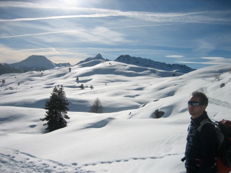
The route starts from the église St. Michel which sits prominently just above the village. An easy ascent follows the hiking path and snow covered slopes heading north from the church. The path soon enters an open river gorge. Here there is some spectacular scenery in the form of huge icicles draped on the cliff walls and free standing limestone towers. The route steepens up a little but after an hour of climbing the summer hamlet of L’Alp du Pied is reached. Here is a great place to have a rest, explore the architecture of the large wooden farm houses and take in the amazing vistas…..to the south towards the Col d’Izoard and the prominent peak of Roche Brune, to the east over rolling snowy terrain to the peaks lining the Italian frontier and westwards to the high glacial peaks of the Ecrins – Mont Pelvoux (3943m) and Ailefroide (3954m).

The route now continues in a northeasterly direction and follows the line of the water intake for Cervières. As you gain height steadily the tree line is soon reached and the terrain becomes more open and rolling. After a further hour the highest shepherds building is reached – the Bergerie de Peyre-Moutte. This is the highest point of the route at 2150m and is another fine view point. Across the valley the layered rocks in the huge cliff face of the Le Lasseron (2702m) catch the eye as well as the peaks of the Ecrins out to the west.

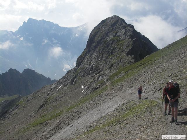
Continuing on a small col is reached where an old military bunker housing can be visited. Also high above there are some fortifications perched on the ridge – all part of the fortifications that once guarded Briancon. Also keep an eye out for chamois as there are usually some around in the sparsely wooded terrain – this area being a reserve for the animals.

Although it is tempting to continue traversing the upper paths in such great scenery a return to Cervières is required and the descent back through the forests must be followed. En route there are numerous spots for posing in front of the cliffs of Le Lasseron. The descent is relatively easy but care must be taken to keep left and avoid the steep slopes directly above the Mur des Aittes (another relic of past war time) which traverses the valley bottom and once guarded the entrance to Cervières from attack.

After the “mur” the route descends easily, meeting the nordic ski tracks and very soon the village of Cervières.

Route: Depart from église St. Michel at Cervières (altitude 1620m). Maximum altitude 2150m (550m of ascent/descent).  Return via Mur des Aittes. Distance 7km. Time 5-6hrs inclusive of stops.

This trek is just one of many options in and around Briancon and La Grave. Fully guided trips of single or multiple days can be arranged with Darren McAulay of French Alps Trekking www.frenchalpstrekking.com


IMG_3334

Tour des Ecrins: GR54

February 13, 2014

The Tour Des Ecrins: GR54
with French Alps Trekking French Alps Trekking
A multi-day trek in and around the beautiful and majestic Ecrins National Park in the Southern French Alps. This mountain trek is regarded as one of the finest long distance walks in Europe and is therefore a must do activity for anyone who enjoys great mountain scenery, unique flora and fauna and some strenous ascents.
Gr54col

An overview of the 6-day Southern section from Vallouise to La Danchere (Venosc)

The 6-day trek begins at a height of 1624m at the road-head west of the village of Vallouise, 20km SW of Briançon. The path follows a wooded valley before climbing up over stony ground and some scree to the first of 2 cols, the Col de l’Aup Martin (2761m). A short traverse over scree leads to the Pas de la Cavale (2735m) before the path descends steeply to the grasslands of the Vallée de Champoléon and the first night’s accommodation at the Refuge du Pré de la Chaumette (1790m; 62 beds).

Day 2 begins with a climb through the Vallon de la Pierre up switchbacks to the first of the day’s 3 cols: the Col de la Vallette (2668) whose ascent requires some easy scrambling. From this col the path drops steeply, but not for long, before crossing a grassy valley to the Col de Gouiran (2597m). The descent from this col is easier than the previous 2 and crosses a series of eroded shaley ribs before climbing to the Col de Vallonpierre (2607m). The distinctive peak of Le Sirac (3441m) dominates much of today’s leg and looms above this last col.
The route now descends steadily to the head of the Vallée du Valgaudemar
which is followed to the night’s destination: the Refuge du Clot (1400m). The refuge provides food and drink and has 50 dormitory beds.

Day 3 begins with an easy valley walk through La Chapelle-en-Valgaudemar
(which is home to several gîtes, a bar/restaurant and a grocery store)to Villar-Loubière. Then it’s a climb to the Refuge des Souffles (1975m), a convenient lunch stop, and then a long climb up switchbacks to the Col de la Vaurze (2498m).

From here you can look directly down on the night’s destination, Le Désert-en-Valjouffrey (1255m), nestling in the valley below although it will take almost 2hrs to reach the hamlet from the col. Le Désert has a bar/restaurant and 3 gîtes, one of which will be home for the night.

Following 3 big days, the walking becomes easier and the days shorter as we
enter the western part of the trek. The scenery becomes a little softer and the cols a little less austere. From Le Désert, the route climbs to the Col de Côte Belle (2290m) before descending through forest to the village of Valsenestre (1294m) which has one gîte containing 25 beds where we will spend the night.

Day 5 is another shorter day and begins with a return back up the previous
day’s route for half an hour before climbing up through grass, then rock, and finally a shale cone to the Col de la Muzelle (2625m). From here the route descends into a grassy valley to the Lac de la Muzelle besides which sits the Refuge de la Muzelle (2130m; 70 beds).

The final day begins with a 90 min climb up switchbacks to the Col du Vallon (2531m) after which it’s downhill all the way to the end of the trek. On the way we pass one of the highlights of the whole GR54, the picturesque Lac Lauvitel (1540m). From here, another 90 mins leads to the village of La Danchere (989m) where we will leave a car.

Overall, the 6-day trek covers 95km and climbs 7260m.

Harstad, Norway: Ski and Sail expedition

April 8, 2011

Ski and Sail  – Harstad, Norway                  March 2011

A week of ski touring on the stunning islands of northwest Norway based on the Anna Rogde (c1868) sailing ship. The trip was organised by David Hamilton for the Eagle ski club (UK). Both David and Darren McAulay were guides for the 13 club members.

For a full account with more photos go to:

http://www.darrenmcaulay.com/Blog/06FF027B-998F-489C-AD76-BCB2057349FA.html

dingy landing for ski touring near Harstad, Norway

dingy landing for ski touring near Harstad, Norway

Harstad sits proudly on Norways largest island Hinnoya and is an important fishing port and commercial centre. This region of northern Norway hosts numerous beautiful islands and mountains (up to 1300m) suitable for ski touring. However, few people have ventured to this ski playground so the trip was partly exploratory for both us and the crew of the Anna Rogde. The ship was used for eating and sleeping but more importantly it provided us with access to islands and slopes that would otherwise be difficult to reach. During the week we met no other skiers (although the weather may have played it’s part in this!).

ski touring above Dale on Grytoya island, Norway

ski touring above Dale on Grytoya island, Norway

Our first forays were on the island of Grytoya – 2hrs sail north of Harstad.  One day to the extremely windy Skjellesvik skardet pass (560m) and the next (a sunny day) skiing above the tiny village of Dale (only 2 inhabitants in winter!) where we climbed Jamnfjellet (802m). There appear to be many other possible peaks to ski on and various traverse across Grytoya.

Our next destination was Andorja island which is said to be the most mountainous island in Norway. During the 2hr voyage we got to hoist some of the sails but then resorted to motor. Strong winds and heavy snow prevented us landing so the night was spent at the more sheltered Lovdal on the mainland.

Next day we returned to Harstad for extra supplies (we were eating far too much of the great food that the chef prepared each day). Also, being protected from the worst of the winds it gave us the chance to ski up the local ski mountain, Sollifjellet (567m) which gave great views to Grytoya and beyond. Although the lift was not operating until the evening (flood lit skiing!) we skinned up three times to the enjoy the fresh, deep powder.  I gave some quick lessons and tips to (hopefully) help improve a few folks technique.

Heading south next day we made for a pier at Raudskier and the mountain Saetertinden (1095m). We skied up through the birch forests – finding some deep snow on the way but turned back at 400m due to avalanche threat and bad visibility. A few turns were enjoyed in the deepest fresh snow yet encountered. The sun arrived just as we headed back to the boat so a few of us were tempted up the small but shapely Harberget (399m) which gave a great descent.

ski touring, ski sail, Norway

Grytoya seen from Sollifjellet (565m) near Harstad

Moving south again we landed on Tjeldoya island this time by the small dingy as there was no safe harbour for Anna Rogde. An interesting day for the scenery (when visible between the heavy snow showers) but again turned back not far above the tree line. A pleasant ski was made back to the coast and then an exciting trip back in choppy swell in the dingy.
Ski touring above Dale, North Norway

High above Dale on Grytoya, island, Norway

Last day and more sunshine!!!! Hooray. We made for Saetertinden (1095m) again but this time via a different route from Elvelund. Again using the dingy to land we had a great climb up to the secondary peak of Haukebotinden (900m) and then the best ski of the week.

That evening saw us return to Harstad and the home mooring for the Anna Rogde.

Thanks again to the Anna Rogde team and the volunteer crew that made the trip possible. Hope to see you again next year! If interested in Ski n Sail 2012 then contact Darren asap. Cheers!

Anna Rogde, Ski n Sail Norway

Just Where Did the Summer Go??

October 19, 2010

Summer-Autumn 2010: ……a quick brief!

June saw plenty of Skye Munros, classic Cuillin climbs and sea cliff adventures. The Old Man of Stoer was summited by Mary n Dafydd before they swapped the Scottish Highlands for the French Alps and some exciting Via Ferrata, multi pitch rock climbing and a wee mountain or two.

On the Cuillin Ridge near Sgurr a Ghreadaidh

Inaccessible Pinnacle, Cuillin, Isle of Skye


The southern section of the GR54 Tour des Ecrins was traversed with a small group in late July. Fantastic Alpine scenery, traversing high cols and eating great food in mountain huts and gites was order of the day here. Flora and fauna in abundance as always in the Ecrins Alps!

High on the GR54 - Tour des Ecrins, French Alps

Refreshments at the Evariste Chancel refuge above La Grave

Refreshments at the Evariste Chancel refuge above La Grave


August saw a return to the UK, starting in Cornwall and finishing with a tour of Scotland. Starting on Skye for some Cuillin classics, then to Torridon for an ascent of the Northern Pinnacles of Liathach….. followed by Aviemore, Aberdeen, Edinburgh and Glencoe – just some of the places on route back to Chazlelet for Sept.

Rocher St. Pierre, Valloire - Via Ferrata

Rocher St. Pierre, Valloire - Via Ferrata

Rocher St. Pierre, bridge crossing

Via Ferrata on Le Rocher St. Pierre, exposed bridge crossing!

Monkey Bridge on Via Ferrata

Monkey Bridge on Le Rocher St. Pierre via ferrata, Valloire


Autumn sunshine in the Alps provided many hot rock days and wonderful walks in the tranquil mountains…..and a few paraglide flights.
Now the snow line is creeping down from the high summits and the frosts a regular morning visitor…..soon be winter activity time again!!
BUT………before the Alpine winter I am returning to the south of the globe. Another three months in Antarctica with plans for a ski to the South Pole (arriving around xmas), ascents of Mt. Vinson and further explorations in the Ellsworth Mountains. Great stuff!!!
See you in 2011.

Darren high on the via ferrata at Arsine, La Grave

Darren high on the via ferrata at Arsine, La Grave

Round the Globe (Apr-June 2010)

July 7, 2010

Robin and Darren head for New Zealand (via Hong Kong on the way and Fiji on the return)

Hong Kong harbour

A quick visit to see Swill and have a look about.

Please don't tell Robin what is on the signpost!

Castle Crag above Lyttleton harbour

Mt. Cook, New Zealand

Moeraki Boulders - doing the geologist bit!

Yellow-eyed Penguin

the Alpine Parrot or Kea

Milford Sound....and not raining!

Inverse Gravitational Effects.....

Robin walking on water at Golden Bay, Takaka

Re visiting the Ohakune carrot

Eddie and his hot rod at Ruapehu

Coastal walking north island

Kayaking over the reefs in Fiji

taking it really easy in Fiji

Antarctica 2009/10 – Ellsworth Mountains Ski Traverse (Part 2 of 2)

February 25, 2010

Ski Traverse from Mt. Vinson to Patriot Hills (via Hercules Inlet).

This expedition was part of the 7summits2sealevel quest and involved skiing over 250km through the Ellsworth mountains. Following remote and unvisited glaciers in one of the most stunning regions of Antartica. The trip is best described by the photos!! The opportunities for exploring the Ellsworth mountains by ski are endless – just contact Darren or ALE if you fancy planning a visit!

The team ready for the off at VBC

The team ready for the off at VBC

Branscomb glacier region, Mt. Vinson, Antarctica

The Branscomb glacier, Vinson Massif, Antarctica

The first day involved finding a safe route through the upper glaciers, down to the huge Nimitz glacier. We took the flat terrain in the top left of the photo towards the Zapol glacier.

skiing across the Cairns glacier towards the Zapol col.

Skiing across the Cairns glacier towards the Zapol col.

On the upper glaciers the skiing was generally  fairly easy. Just a few large crevasses to avoid heading for the col that lead to the Zapol glacier and descent route to Nimitz glacier.

ski line down the Zapol glacier

An aerial view of the Zapol glacier and subsequent route.

Once safely through the heavily crevassed Zapol glacier we started to ski along the huge Nimitz glacier. This ice stream is over 65km in length and runs through the Sentinel Range of the Ellsworth Mountains to meet the even larger Minnesota Glacier.

The Nimitz glacier

The 65km long Nimitz Glacier.

Skiing along the Nimitz glacier

Skiing along the Nimitz glacier

After descending from Vinson Base camp via the Zapol glacier Day 1 finished with a easy 8km ski along the Nimitz glacier. The next day we covered over 30km in between the Craddock massif and the Bastien Range. Stunning scenery and a long ski!

Camp site on the Nimitz glacier

Day 3: Perfect weather at the camp site on the Nimitz glacier

In the afternoon of Day 3 we finally came to the end of the Nimitz glacier only to be met with crevasses and a 30m high pressure ridge as the ice crashed in to the even larger Minnesota glacier. The Minnesota is over 80km in length and some 8km wide. We traversed across the glacier just below the crazy paved scenery known as the Bowie Crevasse field. We were now close to the Heritage Range of the Ellsworth Mountains.

Skiing a blue ice section as we entered the Heritage Range of the Ellsworth Mountains.

Skiing a blue ice section as we entered the Heritage Range of the Ellsworth Mountains.

Two days further on and we started the climb up the 30km long Schneider Glacier. Now we were in the heart of the Heritage Range amongst stunning peaks and perfect glacial scenery.

High on the Schneider glacier after 35km skiing that day.

High on the Schneider glacier after 35km skiing that day.

A long day saw us reach the 1600m high col between the Scheider and Driscoll glaciers. The aerial photo below shows the route. Approaching from high on the right we crossed the col on to the Driscoll glacier which runs left to right in the centre of the view. This region is right in the middle of the Heritage Range of Mountains and affords stunning views.

Driscoll Glacier - aerial view

Driscoll Glacier - aerial view

Driscoll Glacier

Campsite high on the Driscoll Glacier

From the Driscoll glacier we descended on to the Union Glacier. High winds and bad visibility meant we had to stop early one day. The weather continued to be far from perfect for the next two days but we pressed on and reached the Hercules Inlet on Day 9 of the expedition. Day 10 and we were back at Patriot Hills camp tired but happy!

Mt. Fordell west ridge

New routing on the West ridge of Mt. Fordell, Marble Hills

A day off saw some exploring in the Hidden Valley in the Marble Hills and a first ascent of the West Ridge of Mt. Fordell.

Mt. Fordell west ridge

High on the West Ridge of Mt. Fordell

Climbing Mt. Fordell

An airy descent on West Ridge of Mt. Fordell

After the ski expedition and a few days at Patriot Hills I returned to Vinson Base Camp (Jan 12). The last Vinson climbers of the 09/10 season were all successful on the mountain and then it was time to pack up camp for another season.

Vinson base camp

Time to relax at Vinson Base Camp! Thanks again ALE!!

Antarctica – 2009/10 season (Part 1 of 2)

February 15, 2010

Second Season Guiding for Antarctic Logistics and Expeditions/Adventure Network International (ALE/ANI).
I departed Le Chazelet heading for Punta Arenas, Patagonia, Chile on November 5, 2009. Then on November 12, after lots of preparation and packing, we all got in to the giant Ilyushin IL-76 aircraft and set off to the Ice. Following an extremely smooth landing on the blue ice runway (thanks to the work of the advance team) we all began the Patriot Hills camp set up – first up was our personal tents and cook tent. One day of wild winds did not deter the camp building and after a week, with Patriot Hills up and running, the Vinson guide team took the ski plane (Twin Otter) the 220km to the Branscomb glacier on Mt. Vinson (our home for the season).

windy day at Patriot Hills camp, Antarctica

windy day at Patriot Hills camp, Antarctica

Vinson Base Camp, Mt. Vinson, Antarctica. (Nov 09)

Vinson Base Camp, Mt. Vinson, Antarctica. (Nov 09)

This season saw a small, but International, set up team (Chris (USA), Pachi (Chile), Namgya (Nepal) and myself) on the mountain. However, we soon built up the Vinson base camp including communications (HF and VHF radio systems), solar power, waste containers, tents and stores. We then skied up the mountain to prepare Low Camp, the fixed ropes and High Camp before the clients arrived.

Building snow block walls at Low Camp, Mt. Vinson.

Building snow block walls at Low Camp, Mt. Vinson.

Namgya snowmelting for tea! Mt. Vinson 2009.

Namgya snowmelting for tea! Mt. Vinson 2009.

For the first two client programs I was Vinson Base Camp manager. Amongst the numerous tasks this involved keeping a track of all expeditions and teams on the mountain. I was extremely fortunate to get to fly over to the far side of the Vinson Massif with an Austrian team who were to attempt Mt. Tyree (2nd highest in Antarctica). Russell (the Twin Otter pilot) landed us safely on the Patton glacier where we all enthused at the view in this rarely visited part of the Ellsworth mountain range. Not only was Mt. Tyree impressive but the whole Patton glacier was surrounded by stunning peaks including Mts. Gardner, Shear, Morris and Evans peak. Wow!

Vinson Massif, Antarctica from the south.

Vinson Massif, Antarctica from the south.

Mt. Shear, Ellsworth Mountains, Antarctica.

Mt. Shear, Ellsworth Mountains, Antarctica.

Having helped the Tyree climbing group unpack their gear we then flew back all the way to Patriot Hills to pick up more Vinson climbers. Although it was now 11pm the sun was shining and the light extremely clear so the trip through the Ellsworth mountains was superb. Later in December I was going to be leading a ski trip from Mt. Vinson back to Patriot Hills (see Ellsworth mountains ski traverse …report coming soon) so this flight provided me the opportunity to view (from above) the route. Through relatively unexplored terrain the proposed ski route would be descending the 65km long Nimitz glacier, crossing the even larger Minnesota glacier and then on through the Heritage Mountains range to reach Hercules Inlet (the edge of the Antarctic Continent – would be the coastline if the ice melted!) and back to Patriot Hills camp. Over 250km of skiing!!

Patton Glacier flowing north from Mt. Tyree

Patton Glacier flowing north from Mt. Tyree

Twin Otter lands on Patton glacier below Mt. Tyree

Twin Otter lands on Patton glacier below Mt. Tyree

Back at Vinson base the new teams were all getting ready to ascend the mountain…… This season all ALE/ANI clients again reached the summit successfully and safely…..more to come…..

Autumn 2009 plans…..

October 13, 2009

Back in Le Chazelet for October and all is very very quiet. The autumn sunshine is still strong but the nights cooling quickly. Last chance for some rock climbing and wandering before the winter snows. Well, actually I am back off to the summer in the southern hemisphere next month. Antarctica beckons for another season – more work for Antarctic Logistics and Expeditions……so off to the South Pole and Mt. Vinson for 3 months!!
So, get planning those trips and adventures for 2010 and give me a call!!!!

Autumn colours - La Meije from Le Chazelet

Autumn colours - La Meije from Le Chazelet

Inca Explore Trek, Peru – Sept 2009

September 11, 2009

Peru 2009 – Inca Explore Trek – Inca Trail to Machu Picchu

Sept 7: The first morning we visited the pre-Inca site called Huana Pucllana in Miraflores district – this consists of a vast mound constructed of adobe bricks containing many levels and plazas. The afternoon saw perfect conditions for paragliding along the Costa Verde. I spent over an hour cruising to the Marriot Hotel and back whilst Terry, Jules, Chris, Toity and Barney all took a tandem flight also! Great soaring conditions and what better way to view the Lima skyline and Pacific ocean than free flying paragliding.

paragliding past the Marriot hotel in Lima

paragliding past the Marriot hotel in Lima

Sept 8: South on the Pacific highway to the coastal reserve at Paracas. Desert scenery and beautiful coasts. Hotel in town of Pisco which is still recovering after the earthquake of Aug 2007. It will be a long time until Pisco is restored but the friendly welcome (and pisco sour drinks) emphasise the character of the people here.

Pacific Ocean waves at Paracas Nature Reserve

Pacific Ocean waves at Paracas Nature Reserve

Sept 9: Boat trip to the Ballestas Islands -abundant bird and sea life in the guise of Humbolt penguins, Inca terns, Peruvian boobies and sea lions galore. The afternoon saw a sandstorm blow in from Paracas – interesting experience for all before we took the bus south further and on to Nasca.

Sept 10: Flight over the Nasca Lines to see the huge desert drawings and lines. Surreal experience as we looped around the various drawings of hummingbrids, spiders and even an astronaut! The afternoon saw us heading south again. A long journey to Arequipa that was lengthened by the Pacific Highway being closed for an hour as sand dunes covered the surface.

IMGP3659

Flight to the Nasca Lines (ask Terry where the sick bags are!)

Sept 11: Easy day sightseeing in Arequipa – the White City of Peru! Tomorrow we head up to the Colca canyon and on to Lake Titicaca before back north to Cusco for the Inca Trail.

Reed boat on Lake Titicaca, Puno, Peru

Reed boat on Lake Titicaca, Puno, Peru

Sept 18 – Now in Cusco, the Inca capital of Peru. Getting ready for the Inca Trail trek which we start on Sunday. Today the crew are off to see the Inca sites of Pisac and Ollantaytambo in the Sacred Valley. All happy and not too many stomach troubles…….!

Uros (floating) Islands, Lake Titicaca, Peru

Uros (floating) Islands, Lake Titicaca, Peru

Inca Trail 20-23rd Sept.

Inca Trail - the group at the start of the Camino Inca

Inca Trail - the group at the start of the Camino Inca

All happy at the Dead Womans Pass, 4200m high in the Andes!

All happy at the Dead Womans Pass, 4200m high in the Andes!

There it is! Machu Picchu, Peru

There it is! Machu Picchu, Peru

Inca Explore Trek – Peru Sept 2009

September 6, 2009

Had a few days mooching in Lima. The winds have been variable but had two great afternoons soaring along the Costa Verde, Miraflores on the paraglider. Smooth dynamic lift and great views! The rest of the team arrive tonight (Sunday) and then the tour of Inca Peru starts in Pisco and the Nasca Lines.